
Six World War II Era Forts in Portland To See From a Kayak

See the Historic Sites of 1940s Casco Bay on a Kayak Tour
Our recent post titled “Six Historic Forts You Can Visit By Foot or Kayak” covered some of our favorite forts to visit while kayaking on Casco Bay, including Fort Gorges and Fort Scammel. In this post we’re shifting our focus from these forts built more than 150 years ago to the 20th-century military fortifications built on the shores of Casco Bay.
Casco Bay played a critical role in the United States’ naval warfare strategy during WWII, and the bay is scattered with fascinating remnants of this history that you can reach by kayak. This post guides you through six sites we recommend visiting, from the lookout towers of Jewell Island to the massive guns of Battery Steele on Peaks Island.
How & Why Casco Bay Became So Militarized
Before diving into the specific sites, it’s worth discussing how and why Casco Bay became so heavily fortified.
As military technology advanced in the 19th and 20th centuries, the geography of the bay made it increasingly valuable for the military. One trend behind this was the shift of defensive fortifications further and further away from major population centers. More sophisticated airplanes, submarines, armored ships, long range guns, and higher grade explosives made it necessary for enemy forces to be stopped earlier in their approach to prevent them from harming civilian populations or critical infrastructure.
At the same time, the advent of faster and cheaper crafts for moving soldiers and supplies, and communication technologies like radio and telephone, allowed garrisons to be further from population centers without the need for long, vulnerable supply lines. This led to an explosion of military buildings on Casco Bay’s outer islands.
The bay already had many forts by the end of the 1800s, so in many cases the military didn’t have to start from scratch. Instead, existing forts were updated with new armaments and fortifications. But with the outbreak of war in Europe during the 1930s and ‘40s, the southern Maine coast saw more new military construction than had occurred since the Civil War. By the time the U.S. joined WWII in earnest, every inhabited island in Casco Bay had some form of gun battery installed in order to render aid in the event of a naval invasion. During the war, Casco Bay served as the major anchorage for the U.S.’ Atlantic Fleet and a critical resupply station, making it a prime target for enemy forces as well.
Casco Bay’s defense wasn’t just about big forts. A whole system of smaller outposts, lookout towers, and spotters on other islands worked in coordination. This created a web that was far more formidable than its individual parts, while supporting a few key centerpieces in the form of communications centers and large gun emplacements.
Fort Williams –
- Location: Cape Elizabeth
- Built: Late 1800s, major expansions through WWII.
- Evolving Defenses: From massive ship-sinking cannons to anti-aircraft guns, Fort Williams reflects changing wartime threats.
- Now: A picturesque park with sweeping views – hike where soldiers once stood vigilant.
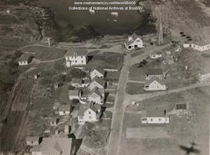
The Cape Elizabeth Radio Direction Finder Station, 1939 – photo from the Maine Memory Network collection
Fort Williams was first established adjacent to Portland Headlight in Cape Elizabeth, shortly after the civil war, as an outpost of the older Fort Preble, which was located closer to the harbor in South Portland. It would expand many times over the next several decades. The 1900s saw the installation of anti aircraft guns and heavy artillery, as well as housing, a hospital, numerous recreation facilities, and communications equipment. During World War II Fort Williams served as the headquarters of the Portland and Casco Bay harbor defenses. However, over the course of the war, Fort William’s role in active combat was steadily drawn down, with its guns moved to or made obsolete by installations in Biddeford Pool, Phippsburg, Battery Steele on Peaks Island, and Jewell Island. The fort remained a logistics and radar station until 1962 when it was officially shut down as a military base. Fort Williams is now a park owned by the town of Cape Elizabeth. In addition to many remains of the fortifications, and the Goddard Mansion, visitors can see both Portland Headlight and Ram Island Ledge Light, use the playground and playing field facilities, or take walks through the woods and along the rocky coastline.
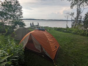
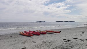
An island camping trip is the best way to see many of Casco Bay’s WWII Forts!
Fort Lyon –
- Location: Cow Island
- Built: 1896
- A small installation protecting Portland’s northern edge
- Now: Used by Rippleffect, a youth outdoor education non-profit, for adventure and learning programs.
A popular lunch or camping spot on our Casco Bay Overnight trips. Half of the island is open to public camping as part of the Maine Island Trail, while the rest is actively used by the environmental education organization RippleEffect, including all of the remaining military structures. Fort Lyon was technically a “sub-post” of Fort McKinley on neighboring Great Diamond Island. Fort McKinley has since been turned into the gated community Diamond Cove, though a small museum and some historic buildings are open to the public.
Jewell Island Battery and Lookout Tower –
- Location: Jewell Island
- Built: WWII
- A sprawling military reservation: 400 troops were stationed on this remote island during WWII
- Now: Climb the many, many steps to the top of the towers for panoramic views.
Jewell Island boasts one of the best views in coastal Maine! From the taller of its two lookout towers, both still accessible to the public, visitors can see all the way from Cape Elizabeth to Cape Small, the entire length of Casco Bay. On clear days Mount Washington can be seen inland and Halfway Rock Light can be seen on its own far out to sea. What’s more, the elaborate underground bunkers and massive gun emplacements built during World War II can be explored for a spooky-feeling look into the past. These factors, as well as the wild beauty and excellent campsites, make Jewell Island a favorite stop for overnight and three day Casco Bay kayak trips.
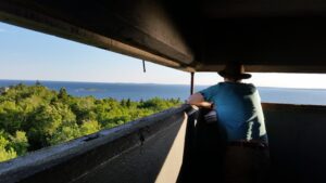
The view from one of Jewell Island’s lookout towers
Jewell Island was the site of several conflicts between indigenous Wabanaki and English settlers during the early settlement periods, however, its distance from major population centers meant formal fortifications were never built. The first major military structures were built during World War II, when Jewell island housed 400 troops, several gun emplacements, and look out towers and searchlights. Careful observation of Jewell’s landscape can still reveal where land was cleared for early sheep farming, and the military’s jeep road can still be used as a walking path. Jewell never saw active combat during the World Wars, but a German U-Boat submarine was sighted by the garrison in 1942, and it participated in efforts to locate another U-Boat in Casco Bay in 1945, following the sinking of the USS Eagle 56.
Battery Steele –
- Location: Peaks Island
- Built: WWI, finished in 1917.
- Big Guns, Big Reach: Its 12-inch guns could fire for miles, keeping any enemy at bay.
- Now: Take the ferry to explore the maze of tunnels and ocean views.
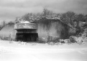
One of the bunkers at Battery Steele – courtesy of the Peaks Island Preserve
Located on the “backside” of Peaks Island, Battery Steele was the centerpiece of Casco Bay and Portland Harbor’s WWII defenses. The “big guns” at Battery Steele were able to shoot up to 26 miles with accuracy, as far away as Cape Porpoise to the southwest and Popham Beach to the northeast. Should enemy ships or aircraft be sighted anywhere along the coast of southern Maine, a network of spotting towers and radio relays would work together to pinpoint their exact location, allowing Battery Steele to target them with impunity. Today Battery Steele is protected by the Peaks Island Preserve, and is a popular destination for a walk, bike, or golf cart adventure after taking a ferry ride over to Peaks. Just barely visible from the ocean, the waters off of Battery Steele are occasionally visited by our Full day tour and rock gardening class.
Two Lights State Park –
- Location: Cape Elizabeth
- Built: 1942
- A critical station overlooking the southern approach to Casco Bay, a tragic loss in the last days of war
- Now: A park with beautiful oceanside cliffs, family friendly equipment, and well preserved tower and bunkers
P2’s Crescent Beach Half day tour regularly visits the waters off of Two Lights, Kettle Cove, and Richmond Island
The former home of the Cape Elizabeth Military Reserve, a critical part of Casco Bay’s defenses during World War II, Two Lights is now a park where visitors can walk on extensive forest trails, rock hop along the craggy headland, picnic and play on playground equipment, and view the historic defensive structures. Make sure to hike up the hill past the picnic shelter to see the iconic fire control tower! Ironically, the lighthouses the park is named for aren’t actually inside the park, but are instead on private property nearby. Two Lights State Park is a great spot to visit on your way to or from Portland Paddle’s Crescent Beach State Park location, just a short drive or bike away.
Just offshore of the CEMR was the site of Caco Bay’s only battle during World War II, when the German submarine U-853 sank the USS Eagle 56 on the 23rd of April 1945 while the Eagle was engaged in training exercises. Casco Bay’s defenders scrambled to locate the attacking submarine to no avail. For many years the attack was deemed a boiler explosion due to the failure to identify the attacker, until historical research led to its reclassification. Thirteen days after attacking the Eagle, U-853 was sunk by US Navy ships off the coast of Rhode Island, the last German ship to be sunk in US waters, mere days before Germany’s ultimate surrender.
Fort Levett –
- Location: Cushing Island
- Built: 1903
- Eyes on the Horizon: A lookout tower scanned for enemy ships.
- Now: Cushing Island is private, but the fire tower can be viewed while kayaking along the cliffs of Whitehead Passage.
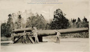
The 12 inch disappearing guns of Fort Levett were installed in the late nineteen-teens or early nineteen-twenties. Some were scrapped during WWII while others continued to see service, despite their vulnerability to airplane attacks – photo from the Maine Memory Network collection
Construction began on Fort Levett in 1898 and was completed in 1903. Upgraded armaments and an entirely new battery were added in 1915 due to the development of armored Dreadnaught-class steamships and the impending threat of American involvement in World War I necessitating increased range and firepower for all of Portland’s harbor defenses. Though Fort Levett is on the private Cushing Island, its fire control tower is visible from many parts of Casco Bay, and is an iconic landmark in its own right. Fire control towers were used during World War II to aid coastal defenses in targeting enemy ships. Tower operators would use spotting scopes to look for enemy ships, artillery splashes, and other clues in order to triangulate the position of an enemy ship, then dial in land based artillery’s targeting. They would communicate with operators at gun batteries via radio or telephone. Towers like this one dotted the entire east coast, and towers as far away as Fort Baldwin in Phippsburg and Cape Porpoise near Kennebunk were involved in defending Portland harbor. Paddlers wanting to get views of the Fort Levett tower can hop on our Fort Gorges or Fort Scammel tours, both of which provide views of the tower from lookout points, or join a half day or full day tour to float right below the tower in the waters of Whitehead Pass.
Following the conclusion of WWII, land based gun placements were deemed largely obsolete and Casco Bay’s military fortifications were steadily decommissioned over the course of the Cold War years. Today, the elaborate bases that supported the war effort are gone, but many of the defensive structures remain. Other evidence of the war can be found all around Casco Bay, such as on Little Chebeague Island, where the remains of a shipboard fire fighting practice station stand, or at Mitchell Field on Harpswell Neck, which served as a fuel depot for Brunswick Naval Air Station. Come out on a tour with us, and visit many of these stunning historic sites!