
How to Plan a Sea Kayak Trip on the Maine Island Trail
Tips for Launching Your Island-Hopping Expedition
If spending too much time away from the water is getting you down, we’ve got the perfect pick-me-up: planning a trip on the Maine Island Trail next summer! The trail extends 375 miles from the New Hampshire border to Canada and includes scores of campsites, so there are lots of options to consider. Whether you are a seasoned expedition paddler or planning your very first overnight sea kayaking trip, careful preparation is key to having a safe and fun experience. We’ve put together this guide to help you get started planning an epic trip on the Maine coast.
Getting to Know the Trail
The Maine Island Trail, America’s oldest recreational water trail, was founded in 1988 by citizens who wanted to encourage stewardship of the coastal islands they loved to visit. The trail has grown steadily since then and today connects over 240 sites and hundreds more shoreside resources. 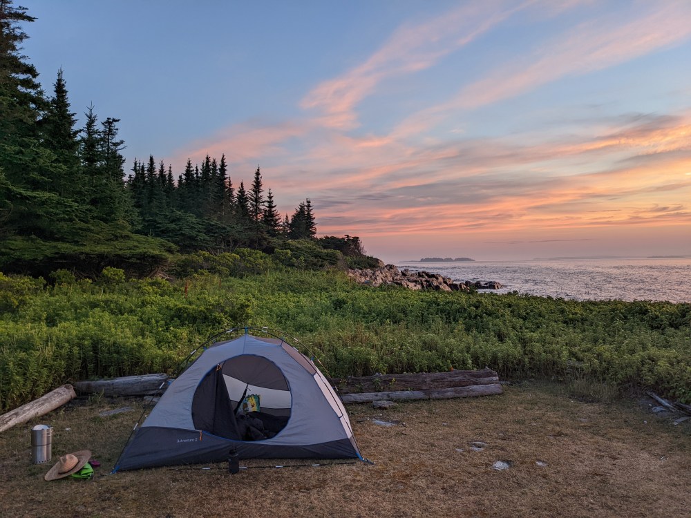
People often assume the Maine Island Trail Association (MITA) owns the islands on the trail, but that’s not how the trail works. Instead, MITA administers the trail by working with public and private site owners, including the state, land trusts, and private families, to allow access to their properties. The trail relies on property owners’ trust that MITA members and other users will be responsible stewards. It’s essential that you practice the Leave No Trace philosophy when you’re traveling on the trail so we can continue to sustain and grow that trust.
For a fuller sense of the trail check out this video documentary, “Journey from Kittery to Lubec on the Maine Island Trail.”
Planning Your Trip on the Trail
Most paddlers explore the Maine Island Trail in short trips focused on a particular region, like Casco Bay or Muscongus Bay, rather than tackling the whole thing at once. That said, every year there are a few adventurous types who do the whole thing in one go. Paddling the entire length of the trail usually takes 1-2 months, though, so if you don’t have that much time you need to decide which section of the trail is the best fit for your trip.
No matter the length of the trip you plan, you won’t be following an established, official route. There are an infinite number of routes that connect the sites on the trail, and the path you travel between them will depend on the weather conditions, your group’s skill and experience level, the vessel you’re using, and your goals and interests. One of the great things about the trail is that every trip is different.
The fact that there’s no official route to follow makes it especially important to plan thoroughly and to learn from the experiences of others who have more experience on the trail. You can tap into a wealth of local knowledge about the trail by talking to local boaters, including staff at outfitters like Portland Paddle. The Maine Island Trail Association’s (MITA) Trail Guide includes lists of outfitters and marinas in each section of the coast. To get a better sense of the possibilities that await you on the trail browse through MITA’s blog or read accounts of those who have paddled the trail, like this one from a Portland Paddle guide. Floating Trails also offers a great starting point to plot different courses as you brainstorm routes based on time-constraints and conditions.
Key Decisions to Make About Your Trip
Before you get far into the trip-planning process you’ll need to make a few key decisions about your trip. Here are some questions you’ll want to address early on:
- Will you join a guided trip or head onto the trail for a self-guided adventure? Portland Paddle and other outfitters offer a wide range of guided paddling trips on the trail. If you don’t have the experience and skills needed to embark on an ocean paddling trip, or you just want to let somebody else handle the logistics, these guided trips are probably your best option. If you’re confident in your abilities — and you have the necessary paddling and camping equipment — then you might prefer a self-guided trip. Keep in mind, though, that Maine’s coastal waters are exposed to a wide range of risks. Check out MITA’s Trail Guide for suggestions about the skills and equipment that are needed to minimize risks.
- What section of the coast will you paddle? Unless you’re paddling the whole trail, you have to choose a geographical focus. Usually that involves picking one of the ten sections of the trail that are identified in the MITA Trail Guide. Some parts of the trail are less protected and offer more challenging paddling conditions than others. And some sections have more campsites to choose from than others. The Downeast section of the trail, for example, is incredibly beautiful, but features lots of exposure to the open ocean and relatively few campsites in some areas. You’ll need to consider those factors as you plan while also taking into account other logistical factors like parking availability at boat launches and travel distance from your home.
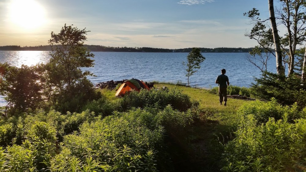
- How much of the trail do you want to explore? Completing the entire trail takes most paddlers a few months (though some expert paddlers go much faster). It’s more common for people to take smaller trips on the trail, and many people try to paddle a different stretch each summer until they’ve completed the whole thing. If you have several days to work with when you’re planning your trip, you can create an itinerary that island-hops throughout a region and potentially reaches some of the more remote and less-frequented sections of the trail. Or you can choose to stay on one island for multiple nights and use it as a base camp as you take day trips into the surrounding area. If you only have one or two days your options are more limited, but there are still plenty of trail sites that can easily be reached for an overnight or day visit.
- Will you paddle a one-way route along the trail or loop back? Many people plan trips on the trail that loop around a bay and end at the same point the trip started. Another option is to plan a one-way route that ends further along the coast. This might allow you to experience more of the trail and see different environments along the coast, but it will require you to arrange transportation back to your starting point. Many outfitters, like Portland Paddle, will provide transportation for one-way routes along the trail. The MITA Trail Guide includes crucial information on where you can launch and where you can park your car overnight (many boat launches do not allow overnight parking).
Joining MITA, Accessing the Trail Guide
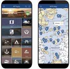
The MITA guide app
MITA embraces the powerfully simple idea that care of the islands can be left to the users of these treasured and fragile places. Islands visited by members tend to be in better shape than those left alone, and every year MITA volunteers dedicate hundreds of hours to cleaning up marine debris from beaches, maintaining campsites, managing invasive plant infestations, and more.
Joining the Maine Island Trail Association as a member allows you to support MITA’s work and get access to MITA’s very useful trip-planning resources. You’ll receive the annual paper Trail Guide and full access to the MITA’s Mobile App, which includes all the information in the paper guide. These are your perfect starting points for planning next year’s adventures (combined with standard nautical charts, of course!).
Portland Paddle guides have lots of experience traversing the Trail, and they offer multi-day tours to popular Trail sites (like Jewell Island in Casco Bay and islands throughout Muscongus Bay), as well as “guided rentals” and equipment rentals and trip planning services for experienced paddlers.So join MITA, give Portland Paddle a call, and look forward to summer on the water.
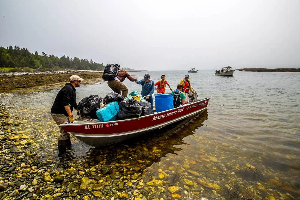
MITA volunteers collecting garbage during an island clean-up day as part of their invaluable stewardship of the trail.